Zoo Bay
Property Overview
Zoo Bay is a 100%-owned, 19,850-hectare uranium exploration property in the northeast Athabasca Basin, covering 15 mineral claims. The basin margin runs directly through the property, providing exposure to both sub-Athabasca (sandstone-hosted) and basement-hosted uranium target types.
Geological Setting
The unconformity occurs at 0-200m depth - significantly shallower than typical Athabasca targets (400-800m). At $250-400 per metre drilling costs, the difference between a 200m hole and a 600m hole is substantial. The basin edge marks the contact zone where Athabasca Group sandstone meets underlying basement rocks - precisely where unconformity-hosted uranium deposits form.
Planned Programs
- Ground Gravity Survey: 2,500-station survey on a 200m x 100m grid to map basement topography, identify structural traps controlling uranium deposition, and generate drill targets
- Designed to advance the property from early-stage to drill-ready by identifying gravity low anomalies - indicators of structural complexity and alteration associated with uranium mineralization
Geophysical Context
Proprietary magnetic field data and historical work guide the survey design, which will generate the first modern structural map of the property.
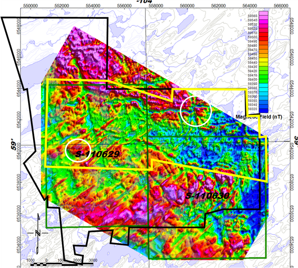
Magnetic field intensity (nT) over the Zoo Bay property. The yellow box outlines the proposed 2,500-station ground gravity survey area on a 200m x 100m grid. White circles mark radiometric anomalies from prior work. This dataset is guiding the survey design.
Gravity images basement density variations - the structural traps controlling uranium deposition. Only legacy 1978-79 VLF-EM data exists in the public record for this area. The planned survey will complete the geophysical picture and identify drill-ready targets.
Exploring Alongside the Majors
Major operators near Zoo Bay

McClean Lake Mill
~60 km SW
District-scale explorer
NE Athabasca Basin
Adjacent claims
NE Athabasca Basin
Rabbit Lake
~70 km S
Hurricane Deposit
~90 km SW
Operator sources: Orano Canada mining & milling (McClean Lake Mill); ATHA Energy Corp. (TSX-V: SASK) corporate disclosure; CanAlaska Uranium Ltd. (TSX-V: CVV) corporate disclosure; Cameco Corp. Rabbit Lake / Cigar Lake operations; IsoEnergy Ltd. Hurricane MRE (July 18, 2022).
Neighboring Deposits
| Deposit | Operator | Distance | Note |
|---|---|---|---|
| McClean Lake Mill | Orano Canada | ~60 km SW | Only operating uranium mill in the region |
| Cigar Lake | Cameco / Orano JV | ~80 km SW | 118.4 Mlb Proven at 16.68% + 74.5 Mlb Probable at 14.73% U3O8 (2024); 16.9 Mlb produced in 2024 |
| Rabbit Lake | Cameco Corp. | ~70 km S | ~186.3 Mlb produced 1975-2011; operations suspended April 2016 |
| CanAlaska Uranium | CanAlaska (TSXV: CVV) | Adjacent | Adjacent claims - active explorer |
Deposit / operator sources: Orano Canada McClean Lake mill; Cameco / Orano Cigar Lake operations page; Cameco Corp. Rabbit Lake (Cameco corporate site); CanAlaska Uranium Ltd. (TSX-V: CVV) corporate disclosure.
Related News
UraniumX Plans 2,500-Station Ground Gravity Survey at Zoo Bay
UraniumX announces plans for a comprehensive ground gravity survey at Zoo Bay, targeting structural controls on uranium mineralization across the 19,850-hectare property on a 200m x 100m grid.
Read Full Release →The scientific and technical information on this page has been reviewed and approved by Ken Wheatley, P.Geo., Chief Geologist, a qualified person as defined by National Instrument 43-101. See site footer for full forward-looking, mineral resource, adjacent property, and US investor disclaimers.