Eastern Athabasca Basin. Every major operator has ground here. The same geological structures that host the world's highest-grade uranium deposits run through this corridor.
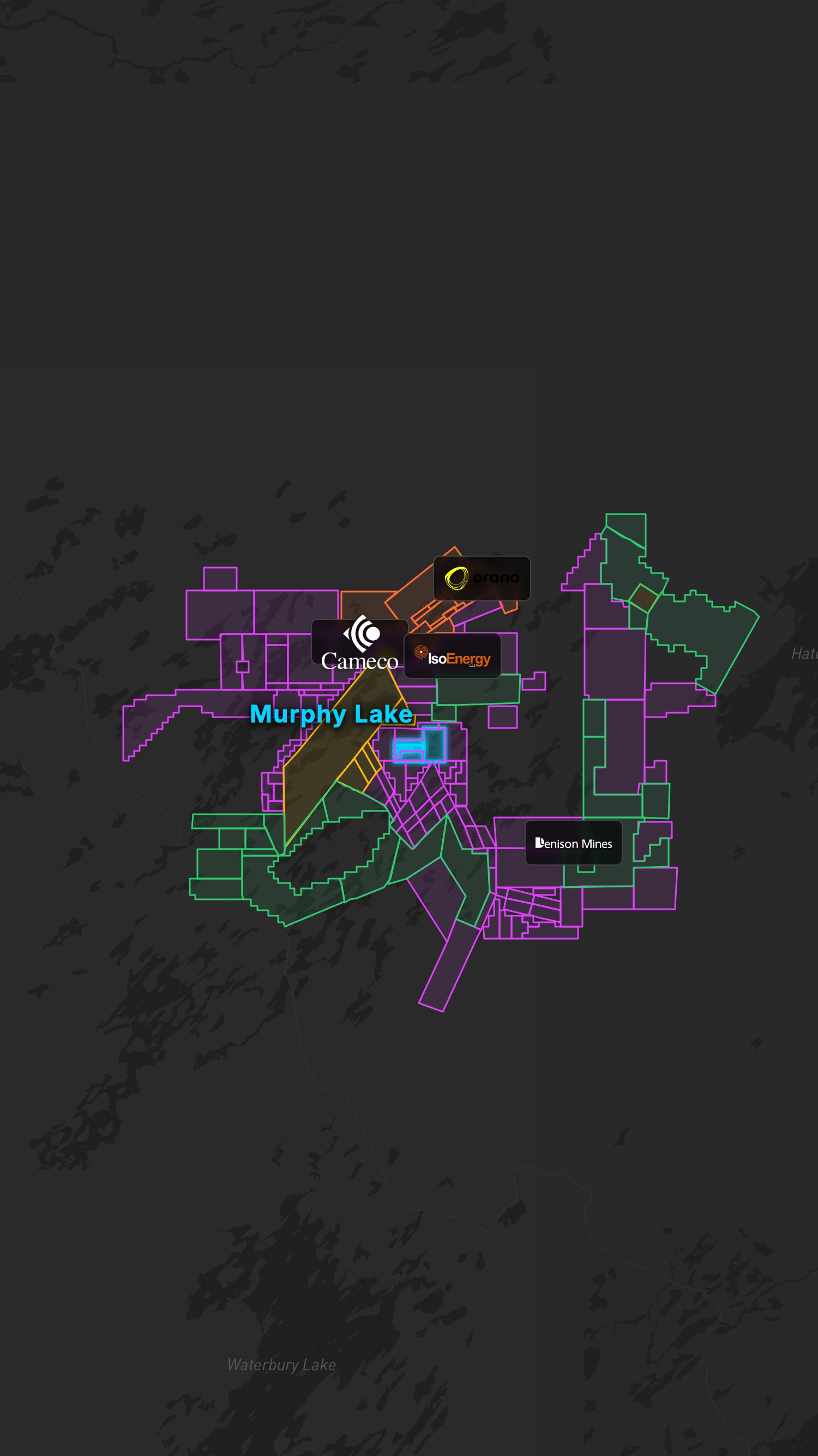
IsoEnergy's Hurricane Deposit - 48.6 million pounds at 34.5% U3O8. Nothing else on Earth compares to this grade.

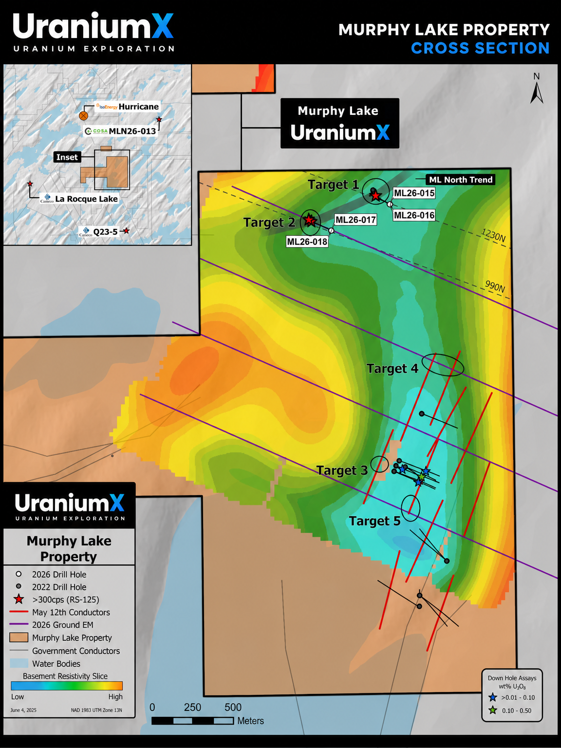
Cosa Resources intersected anomalous radioactivity in three drill holes at their Murphy Lake North joint venture with Denison Mines. The Cyclone trend structural corridor is over 100 metres wide, open 600+ metres along strike in both directions, at only 260 metres depth.
Cameco's La Rocque Zone - 29.9% U3O8 over 7.0m in drill hole Q22-040. 4 km south. The regional geological trend that hosts Hurricane extends along the western edge of our property.
609 hectares. Sitting between Hurricane, La Rocque, and Murphy Lake North. The Larocque Lake conductor trend runs along the western margin of our claims.
ML22-006 returned 0.065% U3O8 over 2.5m at the unconformity contact, including 0.242% U3O8 over 0.5m, within a 4.2m wide deformation zone at 322.5m depth.
No mineral resources have been defined on the property. Exploration results are preliminary.
Holes 1 through 4 of the 2026 drill program all returned the structural, alteration, and radiometric indicators identified by the Company-funded MLEM survey. Hole 1 (ML26-015) returned visible pitchblende above the unconformity. Holes 3 and 4 (ML26-017 and ML26-018) extended the conductive corridor 300 metres along strike. Drilling now advances to Target Area 4 along strike of historical drillhole ML22-006 (0.242% U3O8 over 0.5 metres). Sources: UraniumX news releases dated June 2 and June 9, 2026. Handheld spectrometer and downhole gamma probe readings are anomalous indicators, not assayed grade.
Murphy Lake
Property Overview
Murphy Lake is UraniumX's flagship property, covering 609 hectares in the northeast Athabasca Basin. The property is being explored under an option agreement with F4 Uranium Corp, through which UraniumX can earn up to 70% interest.
Geological Context
Intense hematite and limonite alteration in overlying sandstone, with graphitic shear zones in the basement - consistent with the unconformity-hosted uranium deposit model. Multiple conductors identified through airborne and ground geophysical surveys, with favorable basement geology featuring graphitic pelitic gneiss.
Financing
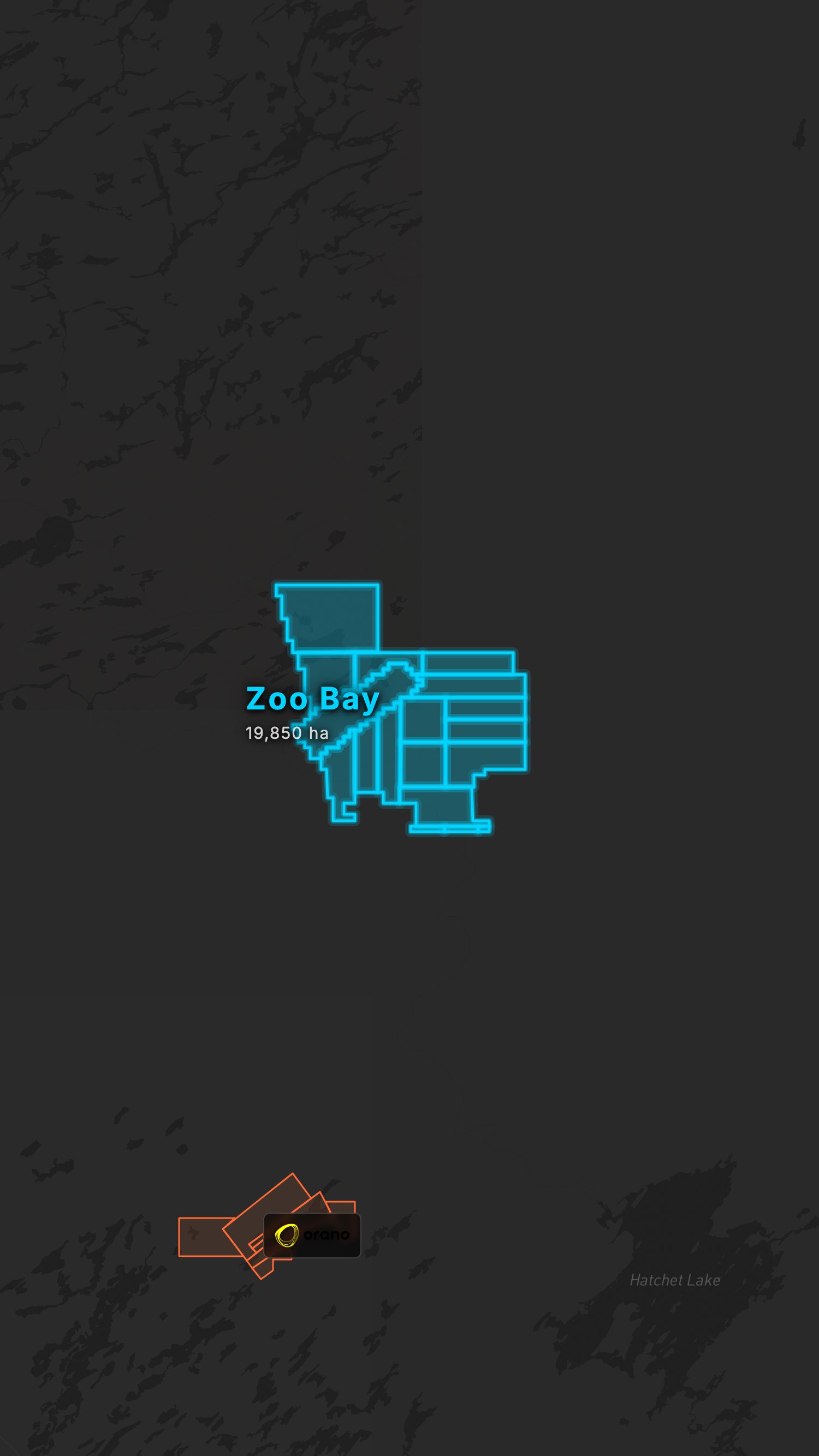
The 2026 flow-through financing is directed toward the active Murphy Lake drill program and Zoo Bay exploration, ensuring both properties are funded through the 2026 field season.
Technical Report
Covered by an NI 43-101 technical report prepared by Terra Modelling Services (Louis F. Fourie, P.Geo.), available on SEDAR+.
Sources: Option agreement with F4 Uranium Corp. (TSX-V: FFU) disclosed in UraniumX / Stearman Resources news releases (July 29, 2025 & Sept 10, 2025) and in F4 Uranium's counterparty disclosure on SEDAR+ (F4 Uranium issuer profile). NI 43-101 technical report authored by Terra Modelling Services (Louis F. Fourie, P.Geo.), filed on SEDAR+ (UraniumX / Stearman issuer profile).
2026 Drill Targets & Murphy Lake North Trend
Target Areas 1 through 5 identified by the Company-funded May 2026 MLEM survey. The four 2026 drillholes (ML26-015, ML26-016, ML26-017, ML26-018) are plotted across the now drill-confirmed Murphy Lake North Trend at the northern end of the property. Cross section lines 1230N and 990N indicated.
Exploring Alongside the Majors
Companies with active claims within 10 km of Murphy Lake

Hurricane Deposit
~5 km N

La Rocque Zone
~4 km S

McClean Lake Mill
~30 km SE

JV with Cosa (MLN)
~3 km E

MLN26-013 result
~3 km E

District-scale explorer
Adjacent
Operator / deposit sources: IsoEnergy Ltd. Hurricane MRE (July 18, 2022); Cameco Corp. operations disclosures; Orano Canada mining & milling page; Cosa Resources / Denison Mines MLN26-013 news release (March 2026); Denison Mines McClean Lake project page; ATHA Energy Corp. (TSX-V: SASK) corporate disclosure.
Neighboring Deposits
| Deposit | Operator | Distance | Note |
|---|---|---|---|
| Hurricane (IsoEnergy) | IsoEnergy Ltd. | ~5 km N | 48.6 Mlb indicated at 34.5% U3O8 |
| Murphy Lake North (Cosa/Denison JV) | Cosa Resources / Denison Mines | ~3 km E | MLN26-013: 5.0m anomalous radioactivity >1,000 CPS incl. 2.5m >5,000 CPS (peak 13,900 CPS) - March 2026 |
| McLean Lake (Orano) | Orano Canada | 30 km SE | Operating deposits |
| La Rocque Zone (Cameco) | Cameco Corp. | ~4 km S | High-grade discovery |
Adjacent deposit sources: IsoEnergy Ltd. Hurricane initial MRE (July 18, 2022) — Indicated: 48.61 Mlb U3O8 at 34.5% U3O8; Cosa Resources / Denison Mines Murphy Lake North MLN26-013 news release (March 2026); Orano Canada McClean Lake operations; Cameco Corp. operations and La Rocque Zone disclosures.
Related News
Ground Geophysics Underway at Murphy Lake
UraniumX provides an update on the 9.2 line-km MLEM ground geophysical survey at Murphy Lake, with EarthEx Geophysical Solutions conducting 4 survey lines to tighten spacing between two conductor corridors ahead of the Spring 2026 drill program.
Read Full Release →UraniumX Commences 9.2 Line-Kilometre Ground Geophysical Survey at Murphy Lake
UraniumX initiates a Moving Loop Electromagnetic (MLEM) ground survey at the Murphy Lake flagship property, targeting conductive structures associated with uranium mineralization.
Read Full Release →Stearman Resources Enters Option Agreement for Murphy Lake Uranium Property
Stearman Resources (now UraniumX) enters an option agreement with F4 Uranium Corp to earn up to 70% of the Murphy Lake property in the northeast Athabasca Basin, located near IsoEnergy's Hurricane deposit.
Read Full Release →The scientific and technical information on this page has been reviewed and approved by Ken Wheatley, P.Geo., Chief Geologist, a qualified person as defined by National Instrument 43-101. See site footer for full forward-looking, mineral resource, adjacent property, and US investor disclaimers.