Athabasca Basin Unconformity Model - Uranium Deposit Types (click to close)
High-resolution resistivity imaging has delineated multiple conductive corridors at the basement-sandstone unconformity - the primary target horizon for Athabasca-type uranium deposits.
The resistivity map images the lower sandstone (SST) horizon. Low-resistivity zones (blue-green, 290–1,700 ohm-m) indicate graphitic basement conductors - the structural and geochemical traps that host uranium mineralization in the Athabasca Basin.
Interpretation of the resistivity data has identified multiple sub-parallel conductive trends striking NNE-SSW through the property. These conductors are consistent with graphitic pelite units along reactivated basement structures - the same geological setting as IsoEnergy's Hurricane deposit 5 km to the north.
Source: F4 Uranium Corp. 2022 drill program; Murphy Lake NI 43-101 technical report by Terra Modelling Services (Louis F. Fourie, P.Geo.) on SEDAR+.
The Summer 2022 drill program completed 14 diamond drill holes testing the western conductor corridor. Hole ML22-006 returned the best intercept: 0.242% U3O8 over 0.5m at 322.5m depth at the unconformity contact.
2022 drill program operated by F4 Uranium Corp. (TSX-V: FFU). Results disclosed in F4 Uranium news releases and the Murphy Lake NI 43-101 technical report by Terra Modelling Services (Louis F. Fourie, P.Geo.) on SEDAR+.
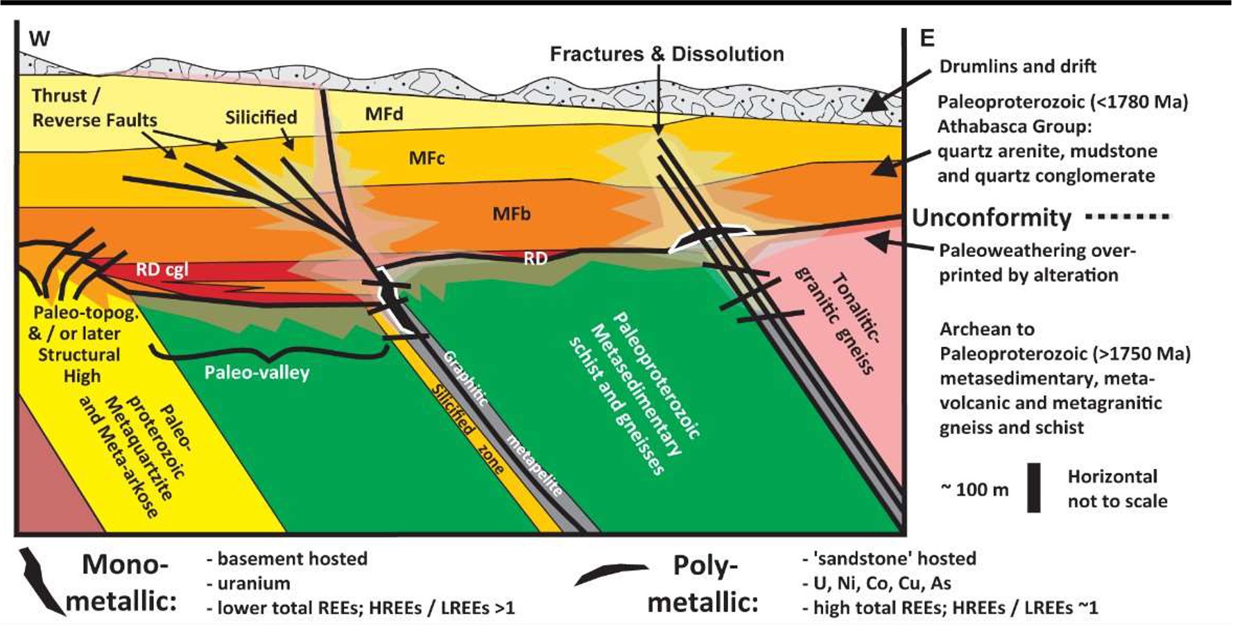
Murphy Lake targets unconformity-hosted uranium at the contact between Athabasca Group sandstone and Paleoproterozoic basement rocks. The geological cross-section below illustrates the deposit model - click to enlarge.
The 9.2 line-kilometre Moving-Loop Electromagnetic (MLEM) survey at Murphy Lake was completed in May 2026 (see news release dated May 5, 2026). The survey extended the prospective conductor system by 1.45 km along strike and defined the priority target areas now being tested by the active 2026 drill program. Drillhole ML26-015 returned visible pitchblende above the unconformity (see news release dated June 2, 2026).
Murphy Lake sits in the northeastern Athabasca Basin, an area with multiple uranium discoveries - approximately 5 km south of IsoEnergy's Hurricane deposit and approximately 4 km from Cameco's La Rocque Zone. Orano's McClean Lake mill is approximately 30 km to the south.
Disclaimers: The Company has not defined any mineral resources or mineral reserves on any of its properties. Mineralization on adjacent or nearby properties is not necessarily indicative of mineralization on the Company's properties. This page contains forward-looking information; actual results may differ materially. Technical content reviewed by Ken Wheatley, P.Geo., Chief Geologist, a qualified person under NI 43-101. Adjacent property sources: Hurricane 48.61 Mlb at 34.5% U3O8 (IsoEnergy Ltd. initial Mineral Resource Estimate, July 18, 2022, news release); La Rocque Zone (Cameco Corp. disclosures); McClean Lake (Orano Canada operations). All figures from public filings on SEDAR+.
Privacy